You see “Gulf access” on Cape Coral listings all the time. But does it mean your boat can actually reach the Gulf the way you plan to use it? If you want smooth weekend runs, reliable fishing trips, or a quick cruise to Pine Island Sound, the details matter. In this guide, you’ll learn what Gulf access really means in Cape Coral, how bridges and canal depth affect your route, typical travel times to open water, and a simple checklist to confirm a property fits your vessel. Let’s dive in.
What “Gulf access” really means
In practice, Gulf access means there is a navigable water route from the property’s canal to the Gulf of Mexico. There are no locks or overland transports required. The real question is how direct and practical that route is for your specific boat.
The quality of access depends on four things. You need to consider fixed bridges and your boat’s air draft, canal and channel depth compared to your boat’s draft, canal width and turning room for your beam and maneuvering needs, and the time it takes to reach unprotected open water.
Direct vs. indirect access in Cape Coral
Direct access means you have a relatively short, bridge-free path to open water with enough width and depth for your vessel. This setup is favored by owners of larger boats and many sailboats. It typically points you to southern Cape Coral canals and areas near established marina corridors.
Indirect access still gets you to the Gulf, but you may pass under fixed bridges, navigate narrower or winding canals, or take a longer route through Pine Island Sound or the Caloosahatchee River. This is very workable for many powerboats. It just requires a clear plan for bridge clearances, tides, and posted speed zones.
The two drafts that matter
Your boat’s draft is how deep it sits below the waterline. It determines the minimum depth you need in canals and channels, especially at low tide. Your boat’s air draft is how tall it is above the waterline. It determines whether you can pass under fixed bridges without waiting for openings or changing your route.
For many buyers, air draft is the bigger surprise. A boat can be fine on depth yet blocked by a fixed bridge. Always compare your vessel’s loaded air draft to posted bridge clearances along the exact route you will use.
Bridges, depth, and channels: what limits you
Fixed bridges are the hard stop for air-tall vessels. Vertical clearance differs by bridge and is published in official bridge tables and nautical charts. Drawbridges operate on set schedules or by request, but fixed spans do not open. Tall sail rigs and flybridge motor yachts must verify clearances before committing to a property.
Canal depth varies by neighborhood and even within a single canal. Residential canals were often designed for small to medium recreational craft. Sections can be shallow at low tide or near the canal sill where the canal meets tidal flats. Shoaling can occur over time, especially in older or less-flushed canals.
Channel width and turning radii matter more than most people expect. A boat can technically fit by draft and still be impractical if there is not enough room to maneuver, back out, and turn safely without risk to neighboring docks and seawalls.
Tides in Southwest Florida are modest, often around 1 to 2 feet. Even so, that difference can decide whether a deeper-draft boat can clear a shallow section. Weather, barometric pressure, and seasonal patterns can also nudge water levels up or down.
Typical travel times to open water
Exact run times depend on where you start, your boat speed, idle and no-wake zones, bridge openings, and weather. Still, some patterns hold true across Cape Coral.
- Very short or near-immediate access, about 5 to 20 minutes: Southern Cape Coral corridors, including areas around Cape Harbour and nearby channels, often offer quick runs to Pine Island Sound or Matlacha Pass at safe transit speeds.
- Moderate access, about 20 to 45 minutes: Many central neighborhoods and western-facing canals fall in this range, with winding routes through interconnected waterways to protected water or popular fishing grounds.
- Longer transits, about 45 to 90+ minutes: Northern and northeastern canals, or routes that rely more on the Caloosahatchee River to reach the Gulf or pass through busier channels, typically take longer. These are still Gulf access but require more planning.
Variables that can add time include waiting on bridge openings, choosing a longer but more sheltered route, and navigating congested passes during peak hours. Sea state also matters. Rougher Gulf conditions can push you to prefer protected water for a longer stretch before exiting.
Matching boat types to neighborhoods
Different boats thrive in different parts of Cape Coral. Use the profiles below to align your vessel with the right canal conditions.
Small center consoles and bay boats
- Typical draft: about 1 to 2.5 feet
- Best fit: nearly all residential canals, including interior and shallower systems
- Why it works: Low draft and compact size make bridges and narrow turns less of a concern
- Ideal use: Inshore fishing, quick hops to Pine Island Sound, flexible day boating
Larger center consoles and express boats
- Typical draft: about 2 to 3.5 feet
- Best fit: Many southern and central canals with reasonable depth and turning room
- What to verify: Depth at low tide and turning radius, plus air draft if you have a tall hardtop or tower
Motor yachts and cruisers
- Typical draft: about 3 to 5+ feet
- Best fit: Deeper canals and direct routes near southern Cape Coral and established marina corridors
- What to verify: Both draft and air draft. Flybridges, radar arches, and hardtops can be limiting under fixed spans
Keelboats and sailboats
- Typical draft: about 4 to 7+ feet, with tall air drafts
- Considerations: Many sailboats are constrained by canal depth and fixed bridge clearance. Vertical clearance on your exact route is essential to confirm
- Practical path: Some sailors choose slips in deeper channels or marinas such as Cape Harbour or along the Caloosahatchee if a residential canal does not suit their vessel
Houseboats and very large vessels
- Reality check: These are rarely compatible with most residential canals
- Practical path: Verify with marina or harbor masters for specific deep-water slips
Neighborhood context you can use
Southern Cape Coral near Cape Harbour is known for shorter runs to Pine Island Sound and more marina services. Buyers who want fast, straightforward access tend to focus here. It is a strong fit for larger center consoles, many cruisers, and select sailboats that can clear route bridges and meet depth needs.
Southwestern canals near Matlacha Pass and Pine Island Sound also offer quick access. Still, it is smart to confirm canal width and watch for shoaling at canal mouths. Conditions can change over time, so plan to verify low-tide depths.
Central and northern canals can offer great waterfront living for small and mid-size powerboats. The tradeoff is longer run times to open water and less margin for deeper drafts. If you own a heavier vessel with more draft, you will want to scrutinize depths closely and account for tides.
Due diligence checklist for buyers
If a listing says Gulf access, treat it as your green light to investigate, not a guarantee. Use this checklist during showings and inspections.
- Ask for canal depth info: Request recent surveys, as-built dredge depths, and any records of maintenance dredging. If none exists, budget for a professional depth survey at mean low water.
- Confirm bridge clearances: Review official bridge tables and nautical charts for every fixed or movable span on your intended route. Compare to your vessel’s loaded air draft.
- Study nautical charts: Look at charted depths, navigation aids, and shoal areas. Compare chart datum to local tide tables so you understand the margin at low water.
- Visit at low tide: Schedule at least one property visit during low tide. It reveals true clearances, bottom contours, and potential trouble spots better than a high tide visit.
- Assess maneuvering room: Walk the canal edge, note neighboring docks, and visualize your turning path. If your boat requires bow thrusters or more space, plan accordingly.
- Inspect seawalls and permits: Verify the condition of the seawall and any existing docks or lifts. Confirm permits and whether seawall replacement or repair is expected.
- Check local rules and HOA: Confirm any restrictions on dock size, lift installations, or vessel types with the City of Cape Coral, Lee County, and any HOA.
- Talk to marinas and yards: Local operators can share practical insights about dredging schedules, shoaling hot spots, and where certain boat types operate comfortably.
- Plan for insurance and storms: Some insurers may want deeper-water moorings or haul-out plans. Know your hurricane plan, including haul-out and protected shelter options.
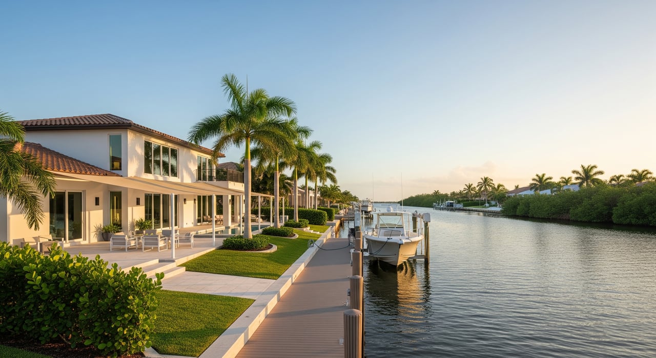
When a marina slip makes sense
Owners of large or tall vessels often pair a waterfront home with a marina slip in a deeper channel. This is common for sailboats with taller rigs and motor yachts with flybridges that push air draft limits. A marina can solve for depth, clearance, fuel, and service access while you enjoy a residential property that fits your lifestyle.
If you are building new, think through dock design, lift capacity, and turning room early. Align your floor plan, seawall improvements, and marine construction permits with your boat’s specs so your final setup works on day one.
How we help you buy or build with confidence
You should not have to guess about water depth, bridge clearances, or build feasibility when purchasing a waterfront home. Our advisory approach focuses on the details that protect your experience and your investment. We help you align property selection with your boating needs, verify access with official resources, and plan any upgrades to your dock, lift, or seawall.
If you are considering a custom build, the partnership between our brokerage and a local builder gives you practical guidance on lot selection, permitting steps, and construction timelines. You gain the comfort of a clear process while we manage the details.
Ready to find the right waterfront fit?
Gulf access in Cape Coral is not one-size-fits-all. It is a spectrum shaped by bridge clearance, canal depth, and your typical run to open water. When you match a property to your boat’s draft and air draft, and confirm the route at low tide, the lifestyle you want becomes dependable and easy.
If you are ready to evaluate listings, compare neighborhoods, or plan a lot-to-build path, connect with our senior advisory team. Schedule your consultation with Potter Trinity and we will create a clear plan tailored to your vessel and your goals.
FAQs
What does “Gulf access” mean in Cape Coral real estate?
- It indicates there is a navigable water route from the property to the Gulf of Mexico, without locks. The route can still involve fixed bridges, shallow sections, or longer transits.
How do fixed bridges affect my boat’s access in Cape Coral?
- Fixed bridges set a maximum air draft for your route. You must compare your vessel’s loaded height to the posted clearance for each bridge you will pass.
How long does it usually take to reach open water from Cape Coral canals?
- Depending on location, typical ranges are about 5 to 20 minutes in the far south, 20 to 45 minutes in many central areas, and 45 to 90+ minutes from northern and northeastern canals.
Which Cape Coral areas offer faster access for larger boats?
- Southern corridors near Cape Harbour and nearby channels often provide shorter, more direct runs to Pine Island Sound, subject to verifying depth and bridge clearance.
What should I check during a showing if I own a deeper-draft vessel?
- Confirm canal depth at low tide, bridge clearances, turning room, seawall condition, and any local or HOA rules for docks and lifts. Consider a professional depth survey.
Is a marina slip better if I own a tall sailboat or flybridge yacht?
- Often yes. Many owners pair a home with a slip in a deeper channel to solve for air draft and depth while keeping their preferred residence location.